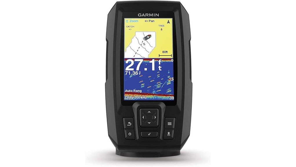
You’ll get a compact, no-frills fishfinder that pairs dependable CHIRP sonar with onboard GPS and Quickdraw Contours for on-the-fly 1‑ft mapping. The 4.3″ sunlight-readable touchscreen is responsive in chop, and GPS lets you drop waypoints and track speed quickly. Mounting and power are straightforward for kayaks, but watch transducer placement and battery management. It’s great value for casual anglers who prioritize portability over networking—keep going and you’ll learn practical setup tips and tradeoffs.
Some Key Takeaways
- Compact 4.3″ sunlight-readable touchscreen delivers responsive controls and clear CHIRP sonar for pinpoint fish detection.
- Built-in GPS locks quickly for waypointing, speed tracking, and integrates with Quickdraw Contours for live contour mapping.
- Quickdraw Contours creates editable 1-foot contours in real time, storing maps up to 2 million acres for detailed bottom capture.
- Lightweight, easy-to-mount design suits kayaks and small boats; plan transducer placement and secure cables during installation.
- Strong value for casual anglers seeking simplicity and portability, though battery life and lack of advanced networking limit long trips.
What the Garmin STRIKER Plus 4 Does and Who It’s For
Pinpoint fish and navigate with confidence: the Garmin STRIKER Plus 4 is a compact, touchscreen fishfinder that combines CHIRP sonar, onboard GPS and Quickdraw Contours mapping to give anglers clear underwater detail and accurate positioning. You’ll use CHIRP to resolve bait and structure, GPS to mark waypoints and build routes, and Quickdraw to generate contour maps on the fly. It’s lightweight, mounts easily to transom or trolling motor, and suits kayak fishermen and beginner anglers seeking straightforward, dependable tech. You’ll get essential sonar fidelity and navigation without complexity, prioritizing practical features over advanced networked functions. Ideal for paddlers, it pairs well with kayaks and accessories sold by specialty retailers for portable fish finder enthusiasts.
Display, Sonar, and GPS: Real-World Performance Tested
While testing on calm lakes and choppy reservoirs, the STRIKER Plus 4’s 4.3″ sunlight-readable display stayed legible and responsive, letting you quickly interpret sonar returns and mark waypoints without squinting or fumbling. You get high contrast readability that holds up in glare and low light, and the touch controls stay accurate when boat motion increases. CHIRP traditional sonar delivers clear returns; sonar noise filtering reduces surface clutter so fish arches and structure stand out. Built-in GPS locks fast, lets you drop waypoints and track speed, and integrates with Quickdraw Contours for immediate contour generation on the fly. This makes it a solid choice for paddlers shopping for kayaks and fish finder batteries who want reliable on-water electronics.
Mounting, Power, and Installation Tips for Quick Setup
Get the STRIKER Plus 4 mounted and powered quickly by planning cable runs, choosing the right mount, and confirming transducer placement before final tightening. You’ll assess mounting compatibility—transom, trolling-motor, or tilt/swivel—to match hull and vibration profile. Map cable routing to avoid chafing and interference; secure with clamps and use supplied power/data cable length efficiently. For battery management, fit an inline fuse close to the battery, monitor voltage, and avoid parasitic drains. Seal maintenance matters: use marine-grade sealant on transducer fittings and protect connectors with dielectric grease. Test on shore before first use to verify operation. Also consider pairing the unit with handheld GPS systems commonly used by water trail enthusiasts to enhance navigation and trip planning.
Quickdraw Contours, Mapping Limits, and Fishing Use Cases
When you run Quickdraw Contours on the STRIKER Plus 4, it creates editable 1-foot contour maps in real time across up to 2 million acres, letting you capture fine bottom detail as you drive transects. You’ll appreciate the contour precision for structure identification and micro-depth changes around drops, humps, and weedlines. Mind the acreage limits when planning multi-lake surveys—2 million acres is generous but finite. Realtime editing lets you refine lines and save actionable waypoints on the fly. Practice storage management: export maps frequently or use microSD to avoid hitting internal limits during extended mapping sessions. This makes the STRIKER Plus 4 a handy tool for kayakers and anglers who need reliable GPS power and mapping on the water.
Should You Buy It? Value, Alternatives, and Final Recommendation
If you’re after a compact, easy-to-use fishfinder that balances core mapping and sonar features with an affordable price, the STRIKER Plus 4 is worth serious consideration. You’ll get reliable CHIRP sonar, Quickdraw Contours, and basic GPS in a rugged, lightweight package. For short trips and casual anglers it’s a strong value: consider battery life constraints if you’re boat-power limited. In price comparison it’s competitive against entry-level units from Humminbird and Lowrance, though those may offer larger screens or networking. Garmin’s customer support options and warranty are solid, supporting decent resale value. Recommendation: buy if you prioritize simplicity and portability. Gear up for Ultimate Water Adventures with kayaks and fish finders to get the most out of portable units.
Some Questions Answered
Does It Support External Maps or Garmin Lakevü Cards?
No — it doesn’t accept LakeVü card cartridges, but you’re covered with microSD support for regional cartography. You can load Quickdraw Contours and compatible regional maps onto a microSD card and insert it, letting you expand coverage and store contours for up to 2 million acres. You’ll manage waypoints and routes from the card, though full preloaded Garmin LakeVü card features aren’t supported on this model.
Can the Unit Be Updated via a Computer or Wi‑Fi?
Yes — you can update the unit via computer, but it doesn’t support Wi‑Fi. You’ll use Garmin Express on your PC or Mac to install software updates by connecting the STRIKER Plus 4 with the supplied power/data cable. There’s no built‑in wireless syncing for firmware or maps, so updates require a physical connection. For waypoint/track transfer you’ll rely on Garmin Express or compatible USB workflows rather than over‑the‑air syncing.
Is the Transducer Compatible With Other Garmin Models?
Yes — the included dual-beam transducer offers broad Transducer compatibility with many Garmin sonar units that accept traditional CHIRP/dual-beam 50/77/83/200 kHz signals. You’ll want to verify pinout and mounting fit for your specific model before swapping. Installation considerations include cable length, connector type, transom vs trolling-motor mounting, and firmware compatibility. If unsure, refer to the Garmin compatibility guide or contact support to avoid damage or reduced performance.
What Are the Waterproofing and IP Ratings?
The unit uses IPX7 waterproofing, so you’ll tolerate immersion to 1 meter for 30 minutes; Garmin specifies ingress protection against temporary submersion rather than dust rating. You’ll still want to avoid prolonged underwater exposure and protect connectors. In practice, you can mount and use it in wet, splash-prone environments confidently, but don’t assume full dust/solid-particle ingress protection since an IPX7 label omits the solid ingress digit.
Does It Lock to Multiple Simultaneous Waypoints/Routes?
No — it won’t lock to multiple simultaneous waypoints/routes; the unit lets you mark and follow a single active route at a time. You can create and store many waypoints, use Waypoints syncing to transfer points between devices, and load routes for navigation, but you can’t overlay multiple active routes for simultaneous locking. Use Route overlay on a connected plotting system or Quickdraw Contours exports for visual comparison instead.